
Introduction
Earthquakes stand as among the most intense unpredictable mega-disasters which occur on our planet. The Earth’s crust energy storage leads to sudden energy release which generates tremors throughout the ground surface.

Seismic energy releases create extensive harm to human settlements together with built structures and natural surroundings. Earthquakes possess the ability to reduce cities to complete ruin while initiating massive destructive phenomena that include tsunamis landslides and fires which result in large fatalities and substantial property damage.
Research about earthquakes becomes crucial due to their far-reaching danger potential that causes vast destruction. Societies throughout the world face significant obstacles because of the destructive forces earthquakes generate which impair infrastructure and force communities to relocating.
The four regions of Japan and Indonesia as well as California and Chile which occupy near-tectonic plate boundaries experience high seismic activity levels throughout the year.
Purpose of Studying Earthquakes
Various important reasons exist for the necessity of earthquake research.
1. Scientists together with engineers use earthquake occurrence knowledge to create efficient buildings codes as well as retrofitting approaches and disaster response systems. The gathered information enables authorities to minimize both catastrophic loss of life and destruction to built structures during earthquakes.
2. Research dedicated to prediction and early warning systems undertakes continuous work to develop systems that warn people of approaching earthquakes with seconds to minutes of notification prior to the oncoming event. The system provides valuable time which enables people to find safety and allows automated systems to stop vital operations.
3. The evaluation of seismic hazard zones allows public authorities alongside organizations to establish strategic choices regarding land utilization and safety preparations for emergencies. Knowledge about seismic hazards enables organizations to develop suitable insurance strategies along with risk-mitigation systems.
4. Earthquakes enable scientists to understand through their analysis how the Earth’s interior looks both in terms of foundations and chemical components. Through seismic wave analysis geologists create detailed maps which identify plate boundaries together with fault lines and geologic features.
5. Earthquakes initiate multiple natural disasters when they occur including tsunamis and the development of landslides and volcanic activity. Scientific investigations into these interactions enable researchers to improve their ability to forecast and reduce compound disaster risks.
6. Through spreading earthquake knowledge people develop a higher level of earthquake understanding which leads them to implement protective behaviors to strengthen their communities against upcoming seismic occurrences.
Definition of Earthquakes
Earthquakes occur when sudden energy releases from the Earth crust make the planet surface shake or vibrate rapidly. The energy release happens because geological faults along with plate boundaries and volcanic activity allows stress to reach its limit.
The pressure that exceeds rock-friction-generated holding forces will trigger explosive movement which generates seismic waves that travel through Earth’s structure.
Earthquakes extend across a wide spectrum because they produce mild tremors which people barely perceive while powerful quakes trigger major devastation. The association between earthquakes and tectonic plate movements remains the most prevalent yet earthquakes additionally originate from volcanic eruptions as well as landslides in addition to human-caused activities like mining and reservoir-induced seismicity and underground nuclear testing.
Overview of Seismic Waves
The Earth receives the seismic waves that carry earthquake energy after the release of seismic energy.
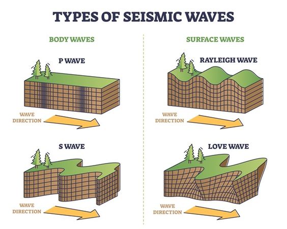
Scientists use seismometers to monitor seismic waves in order to identify the earthquake location and determine its size and depth and the nature of any associated fault structures. Knowledge of seismic wave behavior enables scientists to evaluate both earthquake destruction potential and to design proper monitoring systems.
Causes of Earthquakes
Multiple natural and human activities result in triggering earthquakes. Research into earthquake origins enables scientists to locate places where seismic disturbances are most probable while developing earthquake response methods. Earthquake initiation occurs mainly because of three primary sources which are tectonic plate movements and volcanic events as well as human-manufactured disturbances.
1. Tectonic Activity
Earthquakes that create the most damage result from shifting movements between tectonic plates. The Earth has multiple gigantic physical plates that sail above its asthenosphere trench which conducts semi-fluid movements.
Plates near boundaries produce large amounts of stress which ultimately discharges its stored energy through seismic movement. Three different types of plate boundaries exist between tectonic plates.
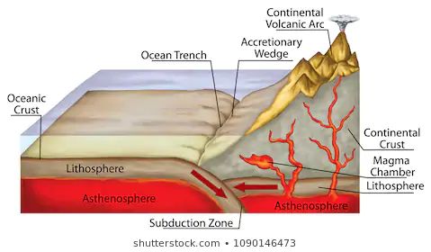
a. Convergent Boundaries (Collisional Boundaries)
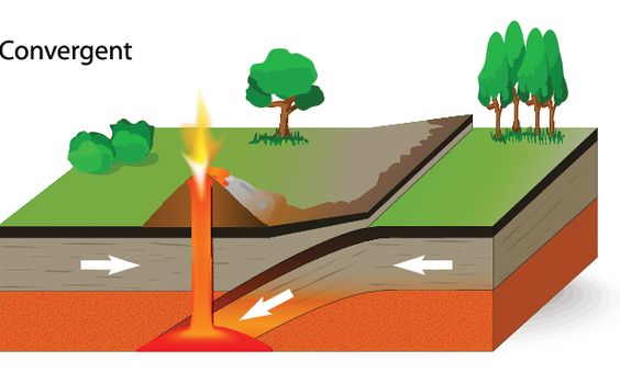
1. The nearest movement of tectonic plates towards each other marks this event.
2. The tectonic plates force one another beneath another plate through a process called subduction.
3. The transferring plate undergoes melting which produces serious stress that leads to massive earthquake occurrences.
4. Deep-focus earthquakes are a common occurrence at convergent plate boundaries because these forms of geological interactions happen below 300 km depths.
b. Divergent Boundaries (Constructive Boundaries)
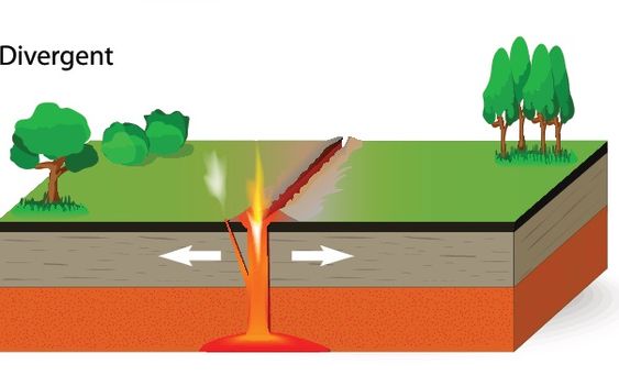
1. Such occurrences develop between two tectonic plates when they move apart from each other.
2. The expansion between tectonic plates results in volcanic magna ascending from beneath the crust to form fresh crustal rocks through cooling.
3. The earthquakes which occur at divergent plate boundaries show shallowness and generate lower levels of power in comparison to earthquakes that form at convergent plate boundaries.
c. Transform Boundaries (Conservative Boundaries)
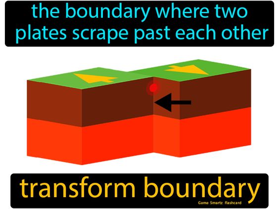
1. Two tectonic plates move opposite of each other in spread motions along these geological boundaries.
2. Seismic waves function as the product of increasing stress occurrence when plates push against each other.
3. Shallow earthquakes occurring at transform boundaries become catastrophic due to their vicinity to Earth’s surface.
2. Volcanic Activity
Volcanic earthquakes occur in regions with active volcanic activity and are generally caused by the movement of magma beneath the Earth’s surface.
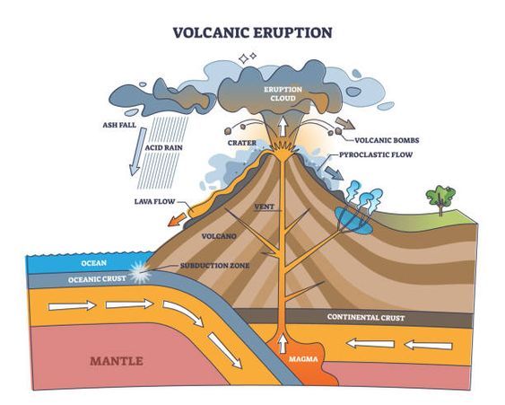
1. As magma rises toward the surface, it fractures surrounding rock, generating seismic waves.
2. These earthquakes are typically localized and of smaller magnitude than tectonic earthquakes but can still be destructive, especially if accompanied by eruptions.
3. Volcanic earthquakes often serve as precursors to volcanic eruptions, providing valuable warning signs for monitoring systems.
3. Human-Induced Causes (Anthropogenic Earthquakes)
Human activities can also trigger earthquakes, particularly when they alter the stress and pressure conditions within the Earth’s crust. Major human-induced causes include:
a. Mining
1. Deep mining operations can destabilize the ground, causing minor to moderate earthquakes.
2. Rockbursts, which occur when the stress in surrounding rock is suddenly released, are a common cause of mining-induced seismicity.
b. Fracking (Hydraulic Fracturing)
1. The process of injecting high-pressure fluids into shale rock to extract natural gas or oil.
2. The increased pressure can trigger small to moderate earthquakes, especially if the fluids reach pre-existing faults.
3. Fracking-induced earthquakes are typically shallow but can cause damage if they occur near populated areas.
c. Reservoir-Induced Seismicity
1. Occurs when large reservoirs or dams alter the stress conditions in the Earth’s crust.
2. The immense weight of water can cause faults to slip, resulting in seismic activity.
3. Changes in water pressure due to filling or draining a reservoir can also trigger earthquakes.
d. Nuclear Testing

1. Underground nuclear explosions can produce seismic waves similar to natural earthquakes.
2. While these events are usually localized, they can cause ground shaking and trigger natural faults to slip.
3. Monitoring seismic activity helps detect and differentiate nuclear tests from natural earthquakes.
Types of Earthquakes
Earthquakes can be categorized into different types based on their origin and the processes that generate them. The four main types of earthquakes are tectonic earthquakes, volcanic earthquakes, collapse earthquakes, and explosion earthquakes.
1. Tectonic Earthquakes
Tectonic earthquakes are the most common and powerful type, caused by the movement of tectonic plates.
1. They occur when stress builds up along faults or plate boundaries due to convergent, divergent, or transform interactions.
2. When the accumulated stress exceeds the friction holding the plates together, the plates suddenly slip, releasing energy in the form of seismic waves.
3. Tectonic earthquakes can occur at any depth but are most destructive when they are shallow and near populated areas.
4. These earthquakes are responsible for the majority of seismic activity worldwide.
2. Volcanic Earthquakes
Volcanic earthquakes are directly related to volcanic activity and typically occur in regions near active volcanoes.
1. They are caused by the movement of magma beneath the Earth’s surface.
2. As magma rises toward the surface, it exerts pressure on surrounding rocks, causing them to fracture and release seismic energy.
3. Volcanic earthquakes can be a precursor to volcanic eruptions, making them important indicators for volcanic monitoring.
4. They are generally localized and of smaller magnitude than tectonic earthquakes but can still cause significant damage if associated with eruptions.
3. Collapse Earthquakes
Collapse earthquakes are small-scale seismic events caused by the sudden collapse of underground structures or caverns.
1. They typically occur in areas with karst topography, where water erodes soluble rock such as limestone, creating caves that may eventually collapse.
2. Mining activities, especially deep mining, can also cause collapse earthquakes when the roof of a mine collapses due to excessive stress or poor structural support.
3. These earthquakes are generally localized and of low magnitude but can still cause damage to nearby structures.
• Example: Collapse earthquakes frequently occur in areas with extensive underground mining operations or natural cave systems.
4. Explosion Earthquakes (Artificial or Induced Earthquakes)
Powerful explosions from human operations generate the specific earthquake type called explosion earthquakes.
1. The primary sources that produce explosion earthquakes include nuclear tests together with chemical explosions along with mining blasts and quarrying operations.
2. The earthquake events which humans cause through explosions tend to remain shallow within local boundaries.
3. Seismic waves produced by such events enable seismometers to identify explosion earthquakes from natural earthquake patterns.
4. The data acquired through explosion earthquakes helps countries enforce nuclear test restrictions per international treaties.
Seismic waves generated by North Korean nuclear test explosions allow worldwide seismologists to conduct analysis of their results.
How Earthquakes Occur
The sudden discharge of energy from Earth’s crust generates earthquakes which then develop as seismic phenomena. The energy release occurs predominantly through tectonic plates moving on faults across plate border regions. The study of earthquake origins includes understanding three essential components which are Elastic Rebound Theory and their categories and locations involving fault systems and plate systems.
1. Elastic Rebound Theory
Geologist Harry Fielding Reid established the Elastic Rebound Theory after observing the effects of the 1906 San Francisco earthquake to explain how earthquakes produce sudden stress releases.
1. Tectonic plate movement produces accumulated stress along crustal faults which represent areas of fractured rock weakness.
2. The rocks located on both sides of a fault deform elastically because they bend to absorb potential energy when exposed to stress.
3. The rocks start to break or slip instantly due to elevated stress levels beyond the relevant friction forces so seismic energy propagates through seismic waves.
4. Rocks readjust after the energy release by “rebounding” into their undeformed original position but may showcase permanentAYOUT changes to their position.
5. The fault’s instantaneous movement produces the ground movements which result in ground shaking during earthquakes.
Science explains the occurrence of most tectonic earthquakes through the Elastic Rebound Theory to support investigations into how stress accumulates before sudden release.
2. Fault Types
A fault represents either a breakage in or weakened area of the Earth’s crust through which rocks separate from each other athletically. Each type of fault exists because distinct plates undergo specific types of stress during their movements. The Earth contains three dominant types of faults which include:
a. Normal Faults (Tensional Stress)
1. Crustal splitting happens under tensional forces which pull the crust in two different directions.
2. On normal faults the upper segment known as the hanging wall experiences downward movement when compared to the lower segment called footwall.
3. Mid-ocean ridges represent some of many divergent plate boundaries where such faults become prominent.
b. The movement of hanging wall blocks upward relative to footwall blocks defines the mechanical characteristic of Reverse Faults also called Thrust Faults under compressional stress conditions.
1. Crush forms when compressional forces push different parts of the crust toward one another.
2. The vertical displacement of the hanging wall occurs in an upward direction as compared to the footwall block.
3. A thrust fault represents a reverse fault characterized by mild dip angles which normally appears next to subduction zones.
4. Plate boundaries that experience plate collision show frequent occurrences of these faults.
c. Strike-Slip Faults (Shearing Stress)
1. Rocks on the edges of faults move side-to-side horizontally against one another during this occurrence.
2. The vertical change is minimal within this fault structure even though the rocks shift extensively from side to side.
3. Transform plate boundaries contain this particular fault feature.
3. Plate Boundaries and Seismic Activity
Earth’s lithospheric plates generate most of the earthquakes that occur when these plates contact with each other. The characteristics of earthquakes that occur increase with the boundary type.
a. Convergent Boundaries (Destructive Boundaries)
1. The convergent plate motion produces two distinct outcomes by pushing plates beneath each other or by causing continental collisions.
2. Ruptures that form at these plate locations release powerful seismic disturbances at different depths below the surface.
3. Common in areas with deep ocean trenches and mountain ranges.
b. Divergent Boundaries (Constructive Boundaries)
1. Plates move away from each other, creating new crust as magma rises and solidifies.
2. Earthquakes at divergent boundaries are generally shallow and less destructive compared to those at convergent boundaries.
3.Often occur along mid-ocean ridges.
• Example: Earthquakes along the Mid-Atlantic Ridge.
c. Transform Boundaries (Conservative Boundaries)
1. Plates slide horizontally past each other, causing significant friction and stress to build up.
2. When stress is released, it generates shallow but often highly destructive earthquakes.
3. Commonly associated with strike-slip faults.
Effects of Earthquakes
Earthquakes can cause devastating impacts on the environment, infrastructure, and human life. Their effects are generally classified into primary effects and secondary effects.
Primary Effects
Primary effects are the direct results of the seismic energy released during an earthquake. They occur immediately during or after the event and are typically confined to the area near the earthquake’s epicenter.
• Ground Shaking
1. The most common and destructive primary effect of an earthquake.
2. Caused by the passage of seismic waves (P-waves, S-waves, and surface waves) through the Earth’s crust.
3. Intensity and duration of ground shaking depend on factors such as magnitude, distance from the epicenter, depth, and local geology.
4. Can cause buildings, bridges, and other structures to collapse, resulting in injuries and fatalities.
• Surface Rupture
1. Occurs when a fault line breaks through the Earth’s surface, creating visible displacement.
2. Can severely damage or destroy roads, pipelines, buildings, railways, and other infrastructure.
3. Surface rupture is typically limited to areas near the fault line but can extend for several kilometers.
• Ground Displacement
1. The permanent movement of the ground due to faulting or subsidence during an earthquake.
2. Can cause cracks, fissures, or vertical and horizontal displacement of the ground.
3. Particularly hazardous to buildings, roads, bridges, and buried pipelines.
4. Can also cause changes in river courses and coastal lines.
Secondary Effects
Secondary effects are indirect consequences of the earthquake that may occur hours, days, or even weeks after the event. They often result from the primary effects and can be more destructive than the initial shaking itself.
• Tsunamis
1. Giant sea waves triggered by underwater earthquakes, particularly those occurring along subduction zones.
2. Displacement of the ocean floor causes a series of waves to propagate outward at high speeds.
3. When these waves reach shallow coastal waters, they increase in height, causing massive destruction.
• Landslides
1. Earthquakes can destabilize slopes and cause massive landslides, particularly in hilly or mountainous regions.
2. Landslides may bury buildings, roads, and entire communities, causing significant loss of life and property.
3. Can also block rivers, creating natural dams that can later fail catastrophically.
• Soil Liquefaction
1. Occurs when saturated, unconsolidated soils lose their strength and behave like a liquid due to intense shaking.
2. Buildings, bridges, and other structures sink, tilt, or collapse when the ground beneath them liquefies.
3. Common in areas with loose, water-saturated sediments, such as river valleys and coastal plains.
• Fires
1. Can be ignited by ruptured gas lines, electrical short circuits, or overturned cooking equipment.
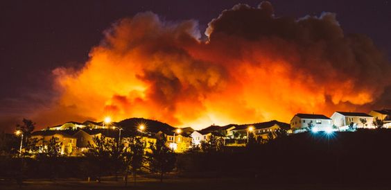
2. Earthquakes can disrupt water supply systems, making firefighting efforts difficult.
3. Fires can spread rapidly, causing additional devastation to areas already impacted by shaking.
Earthquakes in History
There had always been earthquakes injurious to great loss of life, dislocation of infrastructure, and significant alterations in understanding earthquakes, past and present. The only way significant earthquakes befall scientists and engineers in coming up with advanced building practices, disaster preparedness measures, and early warning systems is through studying.
Some important Earthquakes:
–Chile Earthquahke (1960) – The Great Chilean Earthquake
Date: May 22, 1960
Magnitude: 9.5 (the great earthquake)
Epicenter: Near Valdivia, Chile
Impact: Triggered huge tsunamis that swept through Chile, Hawaii, Japan, the Philippines, and other areas across the Pacific Ocean. More than 5000 fatalities and severe infrastructure damage took place.
Significance: Stressed the requirement for tsunami warning systems and contributed toward the establishment of the Pacific Tsunami Warning Center (PTWC).
• Indian Ocean Earthquake (2004) – Sumatra-Andaman Earthquake
Date: December 26, 2004
Magnitude: 9.1
Epicenter: Off the west coast of northern Sumatra, Indonesia
Impact: Causing a disastrous tsunami that hit 14 countries, including Indonesia, Sri Lanka, India, Thailand, and Somalia. Estimated number of deaths from 230,000 to 280,000.
Significance: Demonstrated the absence of a general prompt tsunami warning system in the Indian Ocean region. Because of this, an Indian Ocean Tsunami Warning and Mitigation System-IOTWMS was set up.
• San Francisco Earthquake (1906)
Date: April 18, 1906
Magnitude: Estimated at 7.9
Epicenter: Near San Francisco, California, along the San Andreas Fault
Efforts require ground shaking and extensive burning throughout San Francisco. Approximately 3,000 deaths and 80% of the city was destroyed.
Significance: Increased understanding of the San Andreas Fault and inspired the development of the Elastic Rebound Theory by geologist Harry F. Reid. Improved building codes and urban planning in California.
• Haiti Earthquake (2010)
Date: January 12, 2010
Magnitude: 7.0
Epicenter: Near Léogâne, about 25 km west of Port-au-Prince, Haiti
Impact: Widespread destruction in the capital Port-au-Prince. More than 230,000 deaths, 300,000 injuries, and displaced around 1.5 million people.
Importance: Showed the fragility of poorly constructed buildings and insufficient infrastructure in developing countries. It signposted the importance of disaster resilience, international aid coordination, and disaster preparedness.
Prediction Preparedness
Prediction of earthquakes accurately has remained one of the most important challenges in seismology. The advancement has been through seismic monitoring, data analysis, early warnings, and measures for preparedness, all of which have achieved much toward reducing destruction and casualties related to earthquakes.
Problem of Prediction
• Lack of Predictive Precision
1. Earthquakes aren’t predictable in time, location, and magnitude compared to weather forecasting.
2. The Earth’s crust is incredibly complex, and with so many factors at play, predicting seismic activity with precision is almost impossible.
• Inconsistent Patterns
1. Earthquakes don’t follow a set schedule.
2. While some faults might show signs of stress building up, the timing of when that energy is released can vary widely.
• Insufficient Data
1. In many areas, we simply don’t have enough long-term seismic data, which makes predicting earthquakes quite tricky.
2. Our understanding of how small stress changes can lead to major earthquakes is still limited.
3. Difficulty in Measuring Precursors
4. We’ve looked into things like foreshocks, ground deformation, and gas emissions as possible warning signs, but the results have been all over the place and not very reliable.
Seismic Monitoring
Seismic monitoring is all about keeping a close eye on seismic activity to spot and analyze earthquakes.
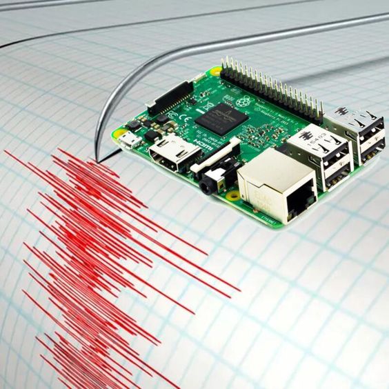
• Seismometers and Seismographs
These are the tools that pick up and record ground movement.
• Today’s seismometers are super sensitive and can even catch the tiniest seismic events.
• Seismic Networks
1. These are networks of seismometers spread out across different regions or even globally to keep tabs on seismic activity.
2. The data collected helps us figure out the location, depth, magnitude, and other characteristics of earthquakes.
• GPS Monitoring
1. This technology helps us detect ground deformation by measuring tiny shifts in the Earth’s crust.
2. It’s particularly effective in monitoring areas near tectonic plate boundaries.
• InSAR (Interferometric Synthetic Aperture Radar)
1. This satellite-based method gives us high-resolution measurements of ground movement over large areas.
2. It’s great for spotting deformation before or after an earthquake.
Historical Data Analysis
Looking at past earthquakes can give us valuable clues about what might happen in the future.
• Paleoseismology
This field studies geological evidence of ancient earthquakes, like fault scarps and sediment layers.
It helps us estimate how often earthquakes might occur and identify areas that are at higher risk.
• Earthquake Catalogs
1. These are comprehensive databases that track historical seismic events, detailing their location, magnitude, depth, and the effects they had.
2. They enable statistical analysis and help assess risks.
• Seismic Hazard Maps
These maps are crafted using historical data, seismic monitoring, and geological studies to pinpoint areas that are at high risk.
They play a crucial role in urban planning, setting construction codes, and preparing for disasters.
• Early Warning Systems
While we can’t predict earthquakes, early warning systems can give us those precious seconds to minutes of heads-up before the ground starts shaking.
• How Early Warning Systems Work
These systems rely on the speed difference between P-waves (which travel fast) and S-waves (which are slower and more destructive). Sensors pick up P-waves and trigger automated alerts before the more damaging S-waves hit.
• ShakeAlert (United States)
This system sends alerts through smartphones, radio, television, and the internet in states like California, Oregon, and Washington.
It can even initiate automated responses, like halting trains and opening fire station doors.
• Japan’s Earthquake Early Warning System
Considered one of the most advanced systems globally, it broadcasts alerts via TV, radio, mobile phones, and public announcement systems.
• Advantages of Early Warning Systems
1. They give people a chance to take protective actions, like ducking, covering, and holding on.
2. They provide essential time for industrial operations, hospitals, and emergency services to get ready.
• Limitations
1. These systems are most effective for distant earthquakes; when it comes to nearby quakes, they often offer little to no warning.
2. Their effectiveness relies heavily on the reliability of infrastructure and communication networks.
Preparedness Measures
Being prepared means planning and educating ourselves to lessen the impact of earthquakes.
• Public Education
1. Raising awareness through campaigns, school programs, and community training is key.
2. It’s important to teach individuals how to respond during and after an earthquake.
• Drills and Simulations
1. Regular earthquake drills help the public get familiar with emergency procedures.
2. Schools, offices, and communities should practice these drills to ensure everyone knows what to do.
• Readiness Plans
1. Encourage individuals and families to prepare emergency kits filled with essential supplies like water, food, first aid items, flashlights, and more.
2. Create evacuation plans and set up safe meeting points for everyone.
• Building Codes and Infrastructure
1. Make sure earthquake-resistant building standards are enforced for new constructions and retrofitting older buildings.
2. Strengthen bridges, dams, and other vital infrastructure to ensure they can handle seismic forces.
• Community Resilience
1. Foster collaboration among local governments, agencies, and residents to build resilient communities.
2. Ensure that post-earthquake response and recovery efforts are quick and effective.
Mitigation and Safety Measures
Mitigation and safety measures are crucial strategies designed to lessen the negative impacts of earthquakes. By adopting effective building practices, crafting disaster management policies, planning land use thoughtfully, and educating the public on safety guidelines, we can significantly reduce the risks associated with earthquakes.
Building Codes and Retrofitting
• Building Codes
Definition: These are regulations and standards set by authorities to ensure buildings are designed and constructed to withstand seismic forces.
Purpose: The goal is to prevent building collapses and minimize damage during earthquakes, ultimately saving lives and reducing economic losses.
• Key Features:
1. Structural Reinforcement: This involves using reinforced steel, concrete, and cross-bracing to boost stability.
2. Flexible Design: Incorporating materials and designs that allow buildings to sway without falling apart.
3. Foundation Isolation Systems: Installing devices that can absorb and dissipate seismic energy.
Examples: The International Building Code (IBC) includes guidelines for earthquake-resistant design. Countries like Japan, California, and New Zealand have some of the strictest building codes in the world due to their high seismic activity.
• Retrofitting
Definition: This refers to modifying existing structures to enhance their resistance to seismic activity.
Purpose:-To modernize older buildings and infrastructure that fall short of today’s safety standards.
• Techniques:-
1. Bracing and Strengthening:-This involves adding steel braces or shear walls to boost the structural integrity.
2. Base Isolation:- Here, we install isolation pads or bearings that help absorb seismic energy.
3. Structural Reinforcement:-This focuses on fortifying weak points like joints, beams, and columns.
Examples:-Retrofitting schools, hospitals, bridges, and historical buildings in areas prone to earthquakes.
• Land-Use Planning
Definition:- This is all about managing land use to lower earthquake risks by steering clear of construction in dangerous zones.
Purpose:- To make sure that vital infrastructure and densely populated areas are situated away from fault lines and unstable ground.
• Approaches:-
1. Zoning Regulations:-These rules limit construction near fault lines, steep slopes, and areas at risk of liquefaction.
2. Hazard Mapping:-We use seismic hazard maps to pinpoint high-risk areas and inform urban planning choices.
3. Building Restrictions:- This includes capping the height and density of buildings in regions susceptible to seismic activity.
4. Greenbelts and Open Spaces:- Creating parks and open areas that can double as emergency shelters during disasters.
Examples:- The California Alquist-Priolo Earthquake Fault Zoning Act restricts building in areas across active faults.
Disaster Management Policies
Definition:-These are the strategies and frameworks set up by governments and agencies to prepare for, respond to, and recover from earthquakes.
Purpose:- To lessen loss of life, minimize economic damage, and ensure a quick recovery after an earthquake.
• Components:-
1. Preparedness:- This involves crafting emergency response plans, evacuation routes, and communication systems.
2. Response:-Making sure search and rescue teams, medical aid, and emergency services are deployed swiftly.
3. Recovery:-Supporting reconstruction efforts, providing financial assistance, and rebuilding infrastructure.
• Examples:
1. The Federal Emergency Management Agency (FEMA) in the United States offers guidelines and resources to help people prepare for and recover from disasters.
2. Japan’s Disaster Countermeasures Basic Act emphasizes the importance of planning before disasters strike, responding effectively during emergencies, and rebuilding afterward.
Personal Safety Measures
• Emergency Kits
Definition: These are prepared kits filled with essential items you might need during an emergency.
• Recommended Contents:
1. Water and Food:- Make sure you have at least a 72-hour supply of non-perishable food and water.
2. First Aid Kit: –A collection of medical supplies to help treat injuries.

3. Flashlight, Radio, and Extra Batteries: -These are crucial for communication and light when the power goes out.
4. Personal Documents:- Keep your ID, insurance info, and emergency contact numbers handy.
5. Clothing and Blankets:- These will help keep you warm and protected.
• Safe Spots
Definition: These are areas inside a building that offer the best protection during an earthquake.
• Recommended Safe Spots:
1. Under sturdy tables or desks.
2. Against interior walls, away from windows, glass, and heavy objects.
3. Areas that are clear of tall furniture that might fall over.
• Safety Guidelines
• During an Earthquake:
1. Drop, Cover, and Hold On: Get down on your hands and knees, take cover under sturdy furniture, and hold on until the shaking stops.

2. If you’re indoors, stay there; avoid doorways unless they’re well-reinforced.
3. If you’re outside, move to an open area away from buildings, trees, and power lines.
• After an Earthquake:
1. Be ready for aftershocks and steer clear of damaged structures.
2. Check for injuries and provide first aid if needed.
3. Avoid using elevators and look out for hazards like gas leaks or structural damage.

Conclusion
Earthquakes are incredibly powerful natural events that can seriously threaten human lives, infrastructure, and the environment. To effectively prepare for and lessen their impact, it’s important to understand what causes them, the different types, how we measure them, and their effects.
By enforcing strict building codes, planning land use wisely, establishing strong disaster management policies, and raising public awareness, communities can significantly lessen the devastating consequences of earthquakes.
Ongoing research, constant monitoring, and advancements in technology are essential for improving early warning systems and building resilience. Educating the public and ensuring preparedness are key to protecting lives and property.
While we can’t stop earthquakes from happening, taking proactive steps can greatly reduce their destructive power and help create a safer future for everyone.